3000 - 5000 B.C.
The area surrounding Peraleda is one of the most important palaeolithic places in Extremadura. A huge number of prehistoric tools have been found here and today they are displayed in many museums both in Spain and abroad. There are also a few ancient dolmens and menhirs spread around Peraleda and nearby villages.
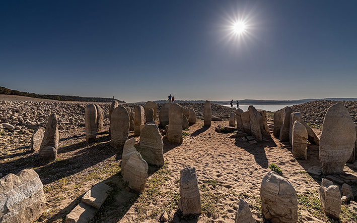
But the king of these monuments is, no doubt, the Dolmen of Guadalperal, nicknamed "the Spanish Stonehenge" by the international press since it made the headlines in almost every country in the world in 2019.
This monument is between 5000 and 7000 years old, which could make of it one of the oldest human constructions. It consists of a group of vertical stones set in a circle. Originally these stones supported a big dome and the whole structure was quite sophisticated. In 1964 a huge reservoir was built, and the dolmen went under water. In 2019 it completely emerged, on dry land for the first time since it was flooded, and the same thing happened again two years later. You need a confluence of very specific factors to see this happen, but climate change and new electricity policies are combining to turn this rare phenomenon in a much more usual one. This is very bad news for its preservation, since changes in its environment rapidly weaken the stones, but also gives you the chance to admire this ancient monument.
Anyway, although seeing it on dry land is indeed a rare sight, the dolmen usually comes partially out of the waters once or twice a year, and it is usually visible pretty much every summer. The best way to see it is by boat. You can order your trip with the only authorized company:
Valdecañas Multiaventura: (+34) 665 19 89 99
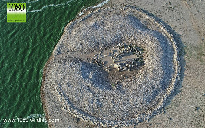
The dolmen was discovered by the German archaeologist H. Obermaier, who excavated it between 1925 and 1927. What we can see today is the skeleton of the dolmen as it was unearthed by Obermaier, a big ring of quartz stones encircling 114 menhirs, many of which are still standing despite the continuous attack of the waters.
It was used as a burial place and a ceremonial centre, among other things, guarding the river ford, one of the only places where people could cross the river Tagus dividing the west half of Spain in two, so this place was hugely important until bridges were built only a few centuries ago. It oversaw the whole crossing from the top of a really high cliff by the river, a cliff which today is slowly sliding down, furtherly endangering the monument. On the other side of the river there was another group of constructions which evolved into a Celtic city first, and then Roman, Augustobriga, today under water too.
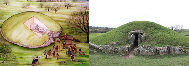
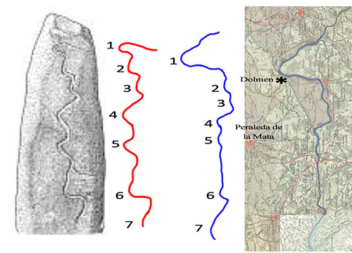
To enter the inner dome there was a corridor, 21 metres long, coming from the river cliff. The dome was 5 metres wide, and it had a menhir-statue, 2 metres high. This big stone was carved in a vague anthropomorphic shape, with some engravings and decoration, and most of all, a waving line which experts think represents a serpent. This line is the most intriguing part of the monument, since recent research has revealed that the alleged serpent is in fact a map of the river Tagus as it flows nearby, depicting a territory flanked by two little tributaries to the north and the south of the site, represented in a very precise manner. If this is true, we are talking about the oldest realistic map in the world, since the only few maps we have from those millennia are schematic. The correspondence is not exact, but we must consider that the person who carved it was doing it from memory, and also that the river course may have changed a bit over the centuries, though the parts flowing between rocky walls are still the same.
It is shocking to see how tradition can sometimes keep memories alive through the centuries, since this place has always been known by locals as "The Treasure". The Romans excavated the area looking precisely for that, a treasure, and German archaeologists found a treasure of artifacts. Today, part of that treasure is in Germany and the rest in Madrid.
Geologists analysed the stones and land and concluded that they were in big danger of destruction. Our association, Raíces de Peralêda (Peraleda's Roots) has been struggling to get it rescued from the waters. Our news got viral and we achieved an incredible impact worldwide, and now archaeologists are doing a lot of research in the dolmen and the area trying to answer some fascinating questions. When we have more data, we may be able to confirm if this monument is one of the oldest man-made structures and one of the most important remnants of prehistoric times. Help us preserve it for future generations, sign here to support our petition.
Photo by Raphael Ruíz:
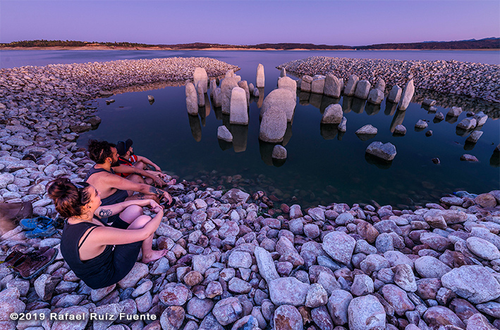
Photo by Raphael Martín:
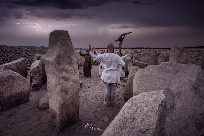
Photo by Javier Sánchez:
Localización:
Escrito por Angel Castańo


